Nazca deforestation
Interview with
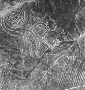
 David - Nazca was a culture which existed on the south coast of Peru. That's in the valleys of Nazca and Ica from round about the time of Christ through to about 500AD. It's famous now because of the Nazca lines which thousands of tourists go to every year and fly over which are giant geoglyphs etched on the surface of the desert pampa which can be seen from the air and give rise to all sorts of extraordinary theories about aliens etcetera ,etcetera. The people who actually produced those lines or most of them were the Nazca people who are the main subject of my interest.
Diana - What does the area look like today?
David - It's the top end of the Atacama desert. It's one of the oldest and driest desert of the world. It never rains there. The only sources of water are the rivers which flow down off the Andes and then into the Pacific. The oases along those rivers were where people lived and these cultures flourished.
Diana - What happened to Nazca culture? Why had they disappeared from the archaeological record by 800AD?
David - Nazca culture - classic Nazca if you like - we know about through a very beautiful art form which is expressed through their textiles and through their ceramics. It's an art form which paints a picture of the natural world and all those fertility factors which underlie agricultural production. That sort of rather conservative artistic canon, if you like, suddenly fractures into three completely different art styles which include themes of war, warriors, depictions of head-hunting. Around the end of the classic Nazca period there are fewer habitation sites and there's also evidence from human skeletons that human life expectancy was falling and mortality was rising. This all adds up to a picture of some major social change going on around about that time.
Diana - How did archaeologists explain this before?
David - The old explanation is an explanation which is generally applied to all culture change in the Andes is that it's caused by an El Nino event. The amount of rain which is deposited on the mountains from the Pacific ocean goes up a huge amount and the rivers flood dramatically. My problem with it is it rather paints a picture of cultures sitting there on the coast of Peru and every now and again being impacted by these big climatic events over which they have no control. Which isn't very satisfying from a point of view form what we know about human cultures around the world.
Diana - What part does the huarango tree have to play in all this?
David - The huarango is a tree from the genus of prosopis and it's the dominant tree species on the coats of Peru. What I argue in my work is that its importance, although we can appreciate its importance quite easily as a human resource, its importance goes far beyond that. It is actually a keystone species in this particular, called riparian, in other words these oases along the rivers. Because it's leguminous it fixes nitrogen into the soil which improves soil quality through that and through a bunch of other effects. It has effects on soil moisture. It creates a microclimate and modifies all these extremes of desert environment to make it a more pleasant place for humans and indeed for other plants and animals.
Diana - So if this tree was pretty essential in maintaining the soil does that mean that Nazca culture went through such a dramatic change because they chopped too many down?
David - That copping down of the trees - a gradual process of human-induced change then exposed the landscape to these El Nino events. The El Nino events in the absence of this gradual change were not the great catastrophes at all. They were times when the water table was replenished and they were probably years of abundance. The reason people were chopping down this tree is of course increased agriculture - in order to clear woodland in order to have larger fields. The landscape essentially was unable to support that level of agricultural production after a certain point in time.
Diana - What lines of data did you have to follow to prove this?
David - First of all and rather obviously there are a whole bunch of relic tree trunks scattered across the landscape which is now completely empty of any vegetation whatsoever. We can record the positions of those tree trunks and therefore record where woodland used to be, where it isn't any more. Secondly we can look at middens. Those are rubbish dumps where people have been disposing of their rubbish in the ancient past to see what they were eating and that can give us a proxy indicator for changed ecological conditions. We can look at pollen. What we can see in those pollen records is a lot of huarango pollen at the bottom of the sequence - in other words going down in time - and then as you go up the sequence, forward in time a gradual falling away of the huarango and indeed of the other trees that make up the riparian woodland: acacia etcetera and agriculture signals appearing in that pollen record. Until we get up to the top of it where we've got a signal which is completely dominated by chenopods and amaranths. Those are weeds effectively: weedy species which grow in agricultural fields and are very tolerant of saline conditions. That's the sort of we get at the top right before we eventually convert into a landscape as it is today which has really, as I say, got no vegetation in it at all.


Comments
Add a comment