Air passenger links between cities internationally are the most powerful determinants of disease spread, new reserach has  shown.
Historically, the spread of infectious diseases tend to be limited by geography, because people moved on foot or on horseback, which imposed constraints on the speed at which an illness could move through a population.
This meant mapping and mathematically modelling transmission of diseases like the Black Death, albeit based on unconfirmed data, was relatively simple.
But modern-day means of travel throw a spanner in the works because, while two cities may be on opposite sides of the world geographically, in air travel terms they can be considered closer to one another than another settlement just up the road from one othe them.
Now scientists have developed a new way to address this problem using a mathematical model that can more accurately predict the spread patterns of diseases internationally and even pinpoint the origins of disease outbreaks.
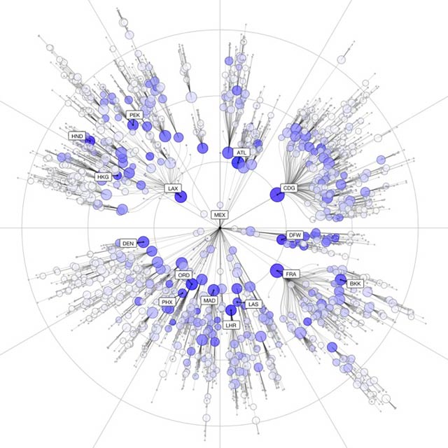
Writing in Science, Humboldt University, Berlin, scientist Dirk Brockmann and Swiss Federal Institute of Technology, Zurich, researcher Dirk Helbing have come up with what they called the "effective distance" Deff between any of the more than 4000 airports internationally.
To do this they developed a formula that takes into account both the infectivity of a given disease and how long a person remains infectious, as well as the proportion of any given population that are travelling through an airport (there are about 10 million passenger journeys per day, globally) and how "connected" that airport is to other airports based on passenger flow.
This means that a remote, but heavily served airport behaves as though it is closer to an outbreak source than a smaller, yet much more proximal airport.
This data can be represented graphically by placing any given airport at the centre of the page and plotting other airports around it in concentric rings according to the "effective" rather than geographical distance from the source airport. Plotted like this, disease outbreaks appear as concentric rings that progressively spread outwards to the more distant airports.
This approach means that Brockmann and Helbing can model where diseases, starting anywhere, are most likely to go and how quickly. To test their approach, they simulated the 2003 SARS oubreak as well as the 2009 emergence of swine 'flu using their system.
In both cases, their predictions produced a near straight-line relationship between the time when either of the two pandemics arrived at any given location and the effective distance (Deff) for that location computed by the new model.
This new work should make it easier to predict disease risks and also to test strategies designed to minimise the spread of emerging pandemics.


Comments
Add a comment