The world has heard much about the Boxing Day tsunami of 2004 and the vast loss of life associated with this, including more than 200,000 deaths in Sumatra, Indonesia, alone.

However, the cause of the tsunami - the great earthquake, magnitude 9.2 on the logarithmic Richter Scale - has not been widely
discussed. That a second great earthquake, of magnitude 8.7, occurred shortly afterwards, on 28th March 2005, which resulted only in a local tsunami, suggests that there is something 'big' ongoing in the tectonic world in this part of the globe. What is behind the earthquakes? Will there be more in this area? Will there be any more devastating tsunami? Read on before you plan a holiday to this surfers' paradise...
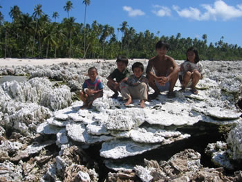 |
Figure 2: Uplifted coral on Pulau Bugi (Bugi island, also sometimes spelled Bogi) in the Hinako islands. Uplift here was ~1.75 m. |
The earth has been recognised as having an outer 'shell' composed of 'plates' that move around on the molten surface beneath. Off western Sumatra the plate tectonic situation is that the Indo-Australian plate is moving against the Eurasian plate, which is being dragged beneath the Eurasian plate, in what is termed a 'subduction zone', down into the heat of the earth's molten mantle. Scientists at Caltech (the California Institute of Technology) are monitoring land movements in Indonesia through a network of Global Positioning System (GPS) points, which assess changes to the earth's elevation against readings from satellite positions. Land movements do not just occur 'coseismically' (with earthquakes); there may also be deformation ('bending') of the earth's surface 'interseismically' (between earthquakes), at a rate that is so slow as to be imperceptible to the human eye. GPS data provide the information on these otherwise indistinguishable movements.
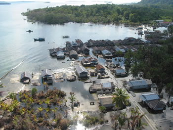 |
Figure 3: The photo shows ~60 cm of subsidence at Haloban village in the Banyak islands. |
What has happened in this area is that the movement between the two plates has become partially 'locked'. Strain builds up over centuries, deforming the earth's surface, and is released in the large earthquakes, which also cause surface deformation, but at an instantaneous timescale. The Caltech scientists, lead by Professor Kerry Sieh, published their latest discoveries in the journal Science on 31st March this year. The island of Simeulue, off the Sumatran coast, marked both the 'end' of the earth movements from 26th December and the 'beginning' of those of 28th March 2005. There is not normally the chance for scientists to study such areas in detail as they are usually on the ocean floor.
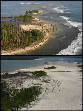 |
| Figure 4: The top panel shows slow interseismic subsidence along the southwestern coast of Nias (notice submerged palm plantation). The bottom panel shows coseismic uplift in March 2005 of about 2.5 m. |
Incidentally, it was the long length of fault rupture - movement occurred over a total distance of 1,600 km - beneath the deep ocean waters that created the world-travelling tsunami wave of 26th December. Uplift of the sea floor in December 2004 was 6m, nearly twice that of the amount in March 2005. (The wave reached Britain on 27th December, with unusual water level changes of + or - 10 cm being recorded at the Newlyn tide gauge in Cornwall, according to data reported by Phil Woodworth and colleagues of the Proudman Oceanographic Laboratory at Liverpool University.) Much of the 400km of length of the fault rupture on 28th March, however, occurred in the vicinity of land, so only a local tsunami was generated on this occasion, as there was no large volume of water displacement involved. Kerry Sieh, Rich Briggs and their co-workers examined both the GPS land elevation change data recorded on Simeulue Island, and the island of Nias to the south, and the coral reefs in those locations
. Uplift of the land meant that many corals were raised out of the water, so they were unable to survive. The scientists found that the northern part of Simeulue was raised by more than a metre on 26th December 2004. On 28th March 2005 it was the turn of southern Simeulue, and areas to the south of it, to undergo a similar amount of uplift. Why should the movement of the earth's crust have stopped with northern Simeulue on 26th December 2004 and have started immediately to the south on 28th March 2005?
The Caltech scientists believe that the dislocation zone may mark what is either effectively a 'tear' in the continental plate at this point or differences in properties of the thrusting behaviour. Movement differs to the north and south of this location as a result. What of the area to the south of that which moved on 28th March? Signs of the interseismic deformation of the earth's crust are clearly present. The strain will be released at some stage - and, if the amount of vertical movement and lateral tear in the earth's crust is sufficiently long, it is possible that an ocean-travelling tsunami may be generated from this movement. However, even a local tsunami could result in large numbers of casualties here, as the Sumatran 'mainland' is both low-lying and heavily populated in this area; a point highlighted by Professor James Jackson of Cambridge University in his lecture 'Surviving Natural Disasters' at Darwin College, Cambridge.
Will the warning systems, currently being implemented, help? Well, probably not for Sumatra, due to the proximity of the land to where the tsunami is generated, as well as the lack of high ground to escape to in some areas. Dr. Rich Briggs of Caltech commented that the best policy in these areas is for people to recognise the danger sign - long (30+) seconds of ground shaking - and then head for higher ground. Professor Sieh and his colleagues distributed information leaflets to the Sumatran population on their visits to the area, to educate the local population as to the dangers. Whilst most of these were in the local languages, some leaflets were also in English, as this is a popular destination for surfers from across the world, who might, otherwise unwittingly, find themselves surfing a rather different kind of wave from that which they were expecting on a visit to Sumatra. Bear this information in mind if you are considering a holiday to that part of Indonesia!
References
- Previous The Science of Well-being
- Next Seeing Red


 crystal")

Comments
This really good information
This really good information for my science project and I hope I can go to this website to get more and more information and "kids who ever have to look up information on the Indonesian earthquake then use this website to get your information and that to write down this information.
Add a comment