Mapping Solar Storm Risk - Planet Earth Online
Interview with
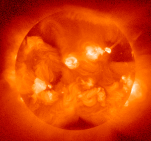
Chris - The Earth is under constant bombardment by particles spewed out by the Sun. They're responsible for the spectacular aurorae - the so-called Northern and Southern Lights.
But solar storms can also disrupt satellites, communications and power supplies and so scientists have now produced the first ever map that shows which regions of the UK power grid are most at risk.
Dr Ciaran Beggan, from the British Geological Survey in Edinburgh, spoke to Planet Earth's Sue Nelson about both the map and the damage that can be done to power grids....
Ciaran - Aurora coincide with large scale changes in the magnetic field and magnetic field changes can induce electric currents in the ground. These are normally very small but when you get very large aurora then the electric fields can be larger. The electric fields or currents tend to flow through the rocks in the ground, but if they become large enough they can then flow through into the power system to the transformers which are connected into the ground.
Sue - Approximately how many of these power station transformers are there around the UK?
Ciaran - There are approximately 600 at the moment and they stretch all the way from the very north of Scotland, all the way down to the south coast of England.
Sue - There have been occasions around the world, famously one in Quebec, where these produce more than just a brief power outage don't they.
Ciaran - Yes, a very famous incident occurred in Quebec in 1989 where a very large geomagnetic storm, the largest one in that decade, caused a transformer to trip in Quebec. Then there was a chain reaction event all the way down the east coast of the US. A similar incident occurred in Sweden in 2003 and that was where, again, a geomagnetic storm triggered a collapse in a transformer which then caused all the electricity in the country to fail.
Sue - So how likely is that to happen in the UK? It is a real possibility?
 Ciaran - It's very hard to say how likely it is. At the moment we're just trying to identify where it might occur and that's what our map has tried to do. So, our map is basically a very simple representation of the UK power grid and what we do is we use the geology of the UK, because that's the controlling factor, to try and figure out how the electricity flows between one part of the UK and another when there is a very large geomagnetic storm. We've discovered that the extremities of the grid are the bits that are most likely to be affected by geomagnetic storms.
Sue - And by extremities you mean, maybe Cornwall for instance.
Ciaran - Yes, so the north part of Scotland is where the electricity tends to go into the grid and it will tend to flow out at the other extremities such as in Wales, in Norwich and in Cornwall.
Sue - Does that mean that the type of rocks in those particular areas, like Cornwall, like East Anglia are the same? What type of rock are we talking about?
Ciaran - Rocks have different electrical properties - so if you have a hard rock like a metamorphic rock or granite, for example, it tends not to conduct electricity very well. The electrical current will tend to flow into the surface, so it's much more likely to then flow into the power grid. Something like chalk or sandstone, which tends to be what the south of England is made from, is actually more porous, it tends to have a little bit more water in it and so the electricity will tend to flow deeper into the ground and that way it will avoid flowing into the national grid.
Sue - So you now know which parts of the UK are most at risk, because there's this map that you've produced and it's never done before. What can the power companies do about it?
Ciaran - One thing that they're going to do is install monitoring equipment at certain regions that are more likely to be effected. Over the years they do know that geomagnetic storms cause problems but they've never been able to understand quite where the problems are. This map will help them identify which regions they should have been installing equipment in and also which transformers they should be monitoring more closely for signs of damage, for example.
Sue - The Sun famously has its 11 year solar cycle, I assume this affects the possibility in the number of geomagnetic storms that you get during these 11 years as well, so what part of the cycle are we currently in?
Ciaran - So we've just come out of a very deep low part of the cycle and we're moving through the middle part of the cycle and it will peak in 2013, around about mid 2013 and it tends to fall off the end.
Sue - So this in fact is perfect timing then? You've produced the map with two years notice effectively for the power stations to act on your information and your advice?
Ciaran - Yeah, that's correct. This has been driven from Government level, there's been a lot of concern in the last couple of years that national hazards to the UK have may be not been studied as much as they could have been. So this is all part of looking at what natural hazards there are threatening the UK at the moment and solar geomagnetic storms are one of them we're looking at way of trying to understand and alleviate those effects.
Chris - Dr Ciaran Beggan from the British Geological Survey talking to Planet Earth podcast presenter Sue Nelson.


Comments
Add a comment