Bringing a ray of sunshine to the studio this week is Alex Hill from the London Met Office, who will be describing how meteorologists predict the weather on a daily basis, Tim Palmer reveals how understanding seasonal weather patterns can help scientists to predict outbreaks of malaria, Emily Shuckburgh discusses how faraway oceans can affect our local weather, Fran Beckerleg braves the roof of the London Weather Centre, and Sheena Elliott joins Derek Thorne in Kitchen Science to shed light on why the sky is blue.
In this episode
Why Snoring May Be a Family Affair
Anyone recognise the familiar sound of snoring? Well, it's more familiar than you might think. Researchers at Cincinnati Children's Hospital Medical centre in the US have found that snoring can run in families. The children of snorers are three times more likely to snore themselves. And if the kids have allergies, then they're also twice as likely to be noisy at night. To get their results, the scientists studied nearly 700 children who were around a year old. This makes the study very interesting, as previous research into snoring kids has focused on older children. Although it seems harmless, snoring can actually lead to discrupted sleep, behavioural problems and even heart trouble. The scientists are now going to follow the children up to the age of 5, to see if their snoring patterns change as they grow.
What Science Will Be Like in 2056
Calling all aspiring science writers! If you're aged 11-18 and want the chance to prove your talents as a science communicator like Dr Chris and Dr Kat, then you should enter Cancer Research UK's latest competition, the Science of Tomorrow. Simply think about what science will be like in the year 2056, and write 700 words on what you imagine. Will all the laboratory work be done by white-coated robots? Or will we all be dead from bird flu, or a more sinister infection? The competition will be judged by a prestigious panel, including Zoe Salmon the Blue Peter presenter, and Tim Radford, ex-science editor at The Guardian. There are some great prizes up for grabs, as well as the chance to publicise your literary talents. Prizes will be awarded for winners aged 11-14 and 15-18, and there are also regional awards. To find out more, and to enter online, visit Cancer Research UK's website www.scienceoftomorrow.org.uk But get your fingers moving fast, because the deadine is April 28th. We're very sorry but the competition is only open to children in the UK.
Why is the sky blue?
Derek - Hello there and welcome this week to Downham Market High School. We've come here this week to the science lab to do some experiments. With me is a new recruit to the Naked Scientists who's going to be doing a few of these kitchen science features for us. Could you introduce yourself and tell us what you do please?
Sheena - My name's Sheena Elliott and I'm a PhD student studying physics at the University of Cambridge.
Derek - Excellent, so what is it we're going to be doing this week?
Sheena - Today we're going to try and do some blue sky experiments. We're actually going to be trying to simulate blue sky in the lab.
Derek - Ok, looking at blue sky. We've also got a couple of volunteers here who've very kindly come down to help us do it. So guys, can you tell us your names and what year you're in here please?
Matt - Hi I'm Matt and I'm in year 10.
Sarah - I'm Sarah and I'm in year 10.
Derek - Thanks guys. I've got to find out whether you're into science because obviously we're out here trying to promote science a bit. So Matt, do you like science?
Matt - Yeah a bit. It's alright.
Derek - And yourself Sarah?
Sarah - Not really.
Derek - So are you open to us persuading you it's actually really cool and fun?
Sarah - You could try!
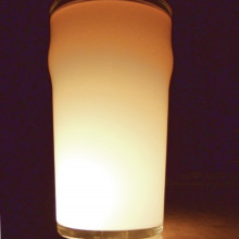
Derek - Ok well we'll be trying to persuade you that science really is very cool. You at home of course can do this experiment as well. It's very very easy. The things you need at home are: some kind of vase or a transparent tall container; also you need a bit of milk; and a torch. That's basically it and now Sheena is going to tell us exactly what we do with all these things.
Sheena - Ok well first of we need to fill the vase or tall glass container to the top with water. We then just need to put in a few drops of milk. We really only need a little amount to put into it. Remember that if you put milk in, you can't take it out so just add a little at a time.
Derek - Well Matt and Sarah are here to try and help us with some of these preparations. We've already got a vase here but we also have some milk and we've got the glass filled up with water. So Sheena, can you instruct them what to do with the milk exactly?
Sheena - Yes. All you need to do is just take the milk, I've got a teaspoon here, and just add less than a teaspoon to the vase and stir it in.
Derek - So that's really a very small amount of milk guys so here we go. And so Sarah, what does it look like in there?
Sarah - Cloudy.
Derek - And so is that mixed enough or does it need to be more mixed?
Sheena - You might just need to stir it a little bit more so it's the same colour all the way through.
Derek - Yeah because it's kind of quite cloudy at that surface at the moment, so Sarah's just stirring it all the way round. And I think that's ok. What next?
Sheena - Now we're going to turn the lights out in the room, take the torch and shine it in through the side, and then look at the colours we observe in the vase.
Derek - What kind of different things, what different angles can you shine the torch from?
Sheena - Well if you start by shining the torch in from the side and then looking at right angles to the beam so we won't be looking directly into the beam. And the secondly, we can look through the vase directly into the beam with the vase in the way of the beam. And then finally, if we shine the beam from below the vase and look from above and see what that looks like.
Derek - Ok so you heard it there from Sheena. You've got to shine a torch into that slightly cloudy vase with the water and a bit of milk in it from a few different angles. Lots of things for you to do there and of course we will be doing that later here at Downham Market High School. Of course, Matt and Sarah are here ready to do it. So Matt, what do you think is going to happen?
Matt - Hopefully the effect we're looking for.
Derek - Well indeed! No more precise than that. Sarah, any idea?
Sarah - No I don't have a clue.
Derek - All sorts of answers there. Well we will certainly be finding out what happens later on. But people at home, you don't have to wait because you can do this right now if you've got these things at home. You can give us a call and tell us the result. We'll be back at Downham Market High School later on to find out what happens and explain how it all relates to things you see around you. Until then it's goodbye.
LATER…
Derek - Hi there once again and welcome back to Downham Market High School where we've got this experiment all ready to go. Sheena's here ready with Matt and Sarah who helped us set up the experiment earlier. So we've got the vase, some water and a tiny bit of milk in there so it's ever so slightly cloudy. We've also got a torch ready to shine through it. But of course, we do need to do this in the dark, so the teacher here at Downham Market is very kindly manning the lights. So, lights please! We're in the dark now. Has anyone got the torch?
Sheena - Yes I have.
Derek - Good I'm glad about that. Ok, so hit the torch, and now what we need to do is for Matt and Sarah to shine some light through this vase and tell us what they see. What direction would you like them to do first them Sheena?
Sheena - So to begin if they just shine the torch into the vase from one side.
Derek - And now what can you see looking across?
Matt - A beam of light going across and the watery milk going blue where the light isn't.
Derek - Ok, so what's the next condition we can try ?
Sheena - So if we shine the light from the same direction but instead of looking at right angles to the beam, we look straight in at the beam from the other side of the vase.
Derek - So Sarah this time, do you want to try that?
Sarah - You can see through the glass. It looks the same.
Derek - Ok Sheena, what's the best way to see the effect we're looking for here?
Sheena - If you compare the colour of the torch beam when it's shone straight onto paper and then compare it to the colour when it's shone through the water and the milk onto paper, see what happens.
Derek - If you shine the beam straight onto paper, what do you see?
Sarah - Just the normal light.
Derek - And if we shine it through the milky water, what do you see then?
Sarah - It goes a lot more orange.
Derek - So Sheena, have we seen the right effect here?
Sheena - Yep. What we've seen is the effect we see with sunlight in the sky. Just to explain a little bit about light first. Light is made up of all different colours. You've got the whole spectrum from blue through to red. When the light shines onto the liquid, you've got little globules of milk. This is an emulsion, which is little globules of milk floating in water. This light comes in and it hits these globules of milk, but the different colours behave in different ways and this is called scattering. Blue light is strongly scattered. Originally when you saw that blue haze, the blue light scattered all over the vase. It was hitting these globules of milk and was being scattered in all directions and we could see this light being emitted from all parts of the water.
Derek - Just quickly, why is it that the different colours of light behave in those different ways? Why does blue scatter?
Sheena - It's a property of how much energy it's got. It's a different wavelength so it's got a shorter wavelength compared to the shorter light and it's also going to be an effect of how big the milk globules are.
Derek - Now, where do we see this effect all around us?
Sheena - So we see this effect every day as we look up into the sky. The sky is blue because the sunlight is shining down towards us but as it's shining towards us it's hitting all these air molecules and being scattered away. When we see a blue sky, we're just seeing the blue light that has been scattered in all directions. We then see it further away from the sun as it bounces into our eyes.
Derek - And so what about when we shone it through and saw that there was more of a red colour on the piece of paper when the torch light was actually going through the milky water? What's going on there?
Sheena - That's basically because we've removed the blue light. Like I said, light is made up of all these different colours, but when we remove the blue light, the white light no longer looks so light. That's'why we see the red because the blue has been removed. If you find that you're not seeing the effect if you've got a small vase or something, if you shine the light up from below so it's travelling through more water, then a lot more of the blue light will be scattered. The light will then appear much more red.
Derek - So of course this reminds us of something we see every day which is…
Sheena - The sun basically. We see a yellow sun because some of the blue light has been removed and scattered around into the sky. Also, when the sun sets, it's actually at an angle to the Earth and coming through a lot more of the atmosphere. This means that a lot more of the blue is taken away and that's why we see these lovely red sunsets.
Derek - Ok Matt, does that all make sense to you?
Matt - Yeah that makes perfect sense.
Derek - Good stuff. And Sarah, our mission here tonight was to convince you that science really is great fun. How have we done?
Sarah - You've done good. I think it's alright now.
Derek - Are you going to change your outlook completely?
Sarah - Maybe a little bit.
Derek - Well that's great. Thanks for doing this experiment with us and thanks to Sheena for setting it up of course, and to Downham Market High School for having us. We'll be back next week for more Kitchen Science that hopefully you can do at home. Until then, it's goodbye from us.
- Tiktaalik
Tiktaalik
with THE FISH THAT FOUND ITS FEET - Professor Neil Shubin, University of Chicago
Chris - Now we're winding our watches back 380 million years now to a time when the first animals began to substitute feet for fins and heave themselves out of the sea and onto land, because believe it or not, we all come from the sea. We all evolved there and the complicated animals became early humans and subsequently modern humans all came out of the sea at some point. Now we know that must have happened and fossils from animals undergoing this transition though are really hard to come by. That's what makes this week's discovery really so important. Neil Shubin from the University of Chicago and his colleagues have uncovered Tiktaalik, and this is a fish which has got all of the features of a primitive wrist, and elbow in some of its limbs and it has very bizarre features. It's got a head rather like a crocodile with nostrils on the side and eyes on the top of its head and ribs. Neil told me earlier why his find is so important.
Neil - The transition from a fish that live sin water to a animal that's able to live on land is one the great transitions in the history of life. We know from a variety of different lines of evidence that this transition happened around 380 to 365 million years ago. We also know the likely players involved, the different kinds of fish that are likely to have given rise to land living animals. Now you know that when we're talking about land living animals, we're talking about a whole branch of the tree of life. This is the branch that includes amphibians, reptiles, birds, mammals and even us. So this is part of our own, albeit very ancient, evolutionary past. The discovery's really important because it's the discovery of a new kind of fish that blurs the distinction between fish and land living animals. It has a mosaic of features seen in both. Like a fish, it has scales, fins and a very primitive jaw. But like a land living animal it has ribs that fit together, it has a neck so the head can move around separately, and it has a flat head like primitive amphibians. Importantly, when you look inside the fin, it has a number of bones that compare very closely to the bones in our own wrist, in our own hand. And so in that sense, it's a real mosaic. It tells us to a great extent how parts of our skeleton evolved.
Chris - Where was it found?
Neil - We found it in a place called Ellesmere Island, which is one of the northernmost island in Arctic Canada, 700 miles south of the North pole. When we work there in the summers, it's daylight 24-hours a day. There are polar bears walking around, there are musk ox, and it's a classic Arctic landscape with ice and glaciers. But between the ice and glaciers, there's bedrock and that bedrock is Devonian aged rock of about 375 million years old. The environments that are contained in those rocks reveal an ancient river or delta ecosystem. Within that delta ecosystem we're finding a variety of fish of which this new kind is just one.
Chris - But a common criticism in the past has been that there are hardly any of these fossils ever found, these transitions from one stage to another.
Neil - Exactly, and this really puts a lid on that because not only do we have a beautiful transitional form but we also have multiple skeletons of it. And when you compare this creature to other creatures that we've known about before: a creature called Panderichthys or Elpistostege, which are creatures that are known from the Baltics or Russia; or when we compare them to the earliest land living animals, a creature known as Acanthostega; when you put this whole series together, it's truly one of the most remarkable transitional series between different kinds of life in the history of the Earth.
Chris - How do you think it came by these interesting adaptations in the first place though?
Neil - Let's think about how this thing lived. What it has is a flat head with eyes on top much like a crocodile. It has nostrils on the side. It's a very flat animal. It has an appendage or a fin that's able to bend its elbow and its wrist. It has a rib cage which suggests that it was able to support itself in gravity. What you have is an animal that's clearly specialising for life on the water bottom, in the shallows or even out in the air for periods of time. So if we look at the geology of the site from where this thing came from, it came from a very small stream in a large delta and giant swampy environment. And it's within these small streams that we believe that we find the locus for the evolution of many creatures that later forms used to walk on land.
- Science Update - Povery and Obesity
Science Update - Povery and Obesity
with Chelsea Wald and Bob Hirshon from the AAAS
Chelsea - For the Naked Scientists this week we'll be talking about a group of scientists trying to alleviate poverty in the developing world. But first, obese people face a heightened risk for all kinds of other conditions like diabetes, heart disease and stroke. Now new research suggests that they may also be more susceptible to pain.
Bob - Exactly. But you might not know it from asking them. That's according to Ohio State University psychologist Charles Emery. He and his colleagues found that compared with non-obese people, obese people's bodies were unusually sensitive to a pain reflex test. The finding dovetails with other research that links obesity to inflammation.
Charles - So you see higher levels of C-reacted protein, proteins we know are associated with inflammation in obese individuals and those inflammatory factors are also found in people with chronic pain. And so it makes a good deal of sense that in fact people who are obese and have this chronic inflammation could be at greater risk for pain.
Bob - Yet in Emery's study, the obese people didn't report feeling any more pain than anyone else. It's not yet clear whether they actually experience pain differently or were just being stoic.
Chelsea - Over the twentieth century, the productivity of that American food staple corn increased more than 1000 times. That's thanks to science. But other crops have been left behind, along with the people who rely on them.
Bob - One crop in particular is cassava, also known as manioc. It feeds some 700 hundred million people in the poorest countries but it's susceptible to viruses, insects and drought. That leaves cassava farmers with hardly enough to feed their families, much less any excess to sell. That's according to plant biologist Claude Fauquet of the Donald Danforth Plant Sciences Center in St. Louis Missouri. He's a leader in an international coalition of scientists working on the cassava plant.
Claude - So it boils down to the fact that if the plant itself is not capable of producing enough calories per unit of space and family, then these people cannot get out of poverty. So we estimate that if we could double the productivity of the current world average productivity, which is about ten tonnes per hectare, if we could turn this into twenty tonnes per hectare then these people could get out of this poverty cycle and could start to participate in the local economy.
Bob - They hope to do this by genetically modifying the plant for resistance to drought, viruses and pests and to express healthy vitamins and proteins. But they caution that current investment in cassava plant research is only one per cent of what they need to reach their goal.
Chelsea - Well that's all for this week's Science Update. Next time, along with the Naked Scientists, we'll be talking about marine science. Until then, I'm Chelsea Wald.
Bob - And I'm Bob Hirshon for AAAS the science society. Back to you Naked Scientists.
- Venus Express Prepares For Orbit Insertion
Venus Express Prepares For Orbit Insertion
with Dr Daniel Scuka, European Space Agency
Daniel - Later this week on Tuesday April 11th, the European Space Agency's Venus Express begins its critical orbit insertion manoeuvre designed to break the spacecraft and lower it neatly into a twenty four hour elliptical orbit around the hot house planet. While it sound easy, it's actually a challenging and fraught manoeuvre. The focus of activity that day will be the main control room or MCR at ESOC, ESA's Space Operations Centre in Germany. During a recent live training session, I met Mike McKay in the MCR. Mike is a veteran ESA flight director who has spent many hours on console in this room.
Mike - On the large screens in front of us we can see data such as the ground station status, where we are actually picking up the spacecraft and at what time, critical events will be displayed so that all the key members are focussed on the critical schedule of events that must occur for successful Venus insertion.
Daniel - Mike says the well equipped main control room enables the flight controllers work as a focussed team during critical events such as launch or orbit entry, and gives them the central facilities they need to communicate with support teams worldwide. I asked him to describe some of the high tech drama that takes place here when multi - million Euro missions are launched or manoeuvred deep in space.
Mike - As you can imagine in a room like this where you have to make the right decision in sometimes seconds to save a mission, emotions get very high. Flying a spacecraft to another planet and successfully putting it into orbit millions of kilometres from the Earth, that is really the high that you get in this room. There can also be disappointments. When you're training a team weeks or months in advance for an event like a launch and find at the last minute that there's something not quite right, we can get a delay for days or maybe even weeks and months, and that is sometimes hard to take.
Daniel - He describes what will happen here at 0819 GMT on the morning of April 11th when Venus Express fires its main engine to be captured into Venus orbit. Mission controllers will monitor the manoeuvre carefully via an S-band signal sent form the spacecraft.
Mike - Tracking that signal through the burn will allow us to see the changes in frequency of the signal that are caused by the spacecraft speeding up. So we can actually monitor indirectly that the burn is taking place. It really is the critical aspect of the operation for Venus orbit insertion to see the main engine has functioned correctly. It will then disappear behind Venus and we will have no signal. That will mean the excitement in here will be very intense, to see if after that period of eclipse behind Venus, will it pop out again, will we get a signal? So I can imagine here that the excitement is going to be very very intense on that day.
Daniel - On April the 11th, ESA will provide up the minute reports on Venus Express and Europe's arrival at Venus for what is shaping up to be one of the most significant science missions in the agency's history. For more news and information on the worldwide web, access www.esa.int. For the European Space Agency, I'm Daniel Scuka reporting from the European Space Operations Centre in Darmstadt, Germany.
- How To Forecast The Weather
How To Forecast The Weather
with Alex Hill, Head of the London Met Office
Chris - Tell us, what goes in to making a weather forecast?
Alex - Information. Vast amounts of information just about sums it up really. We have everything from satellites to men, to aircraft to get a description of how the globe is behaving at one particular time, so at the start of the day for example. Then the great number cruncher in the sky which we call our Met Office computer then integrates over large numbers of differential equations for thousands of spots and thousands of feet up in the air. So we essentially describe the atmosphere in a computer.
Chris - But what sorts of things are you measuring to do that?
Alex - Actually just two things principally: just wind and temperature. Everything else can be derived from that. You get an idea of wind and temperature and you get an idea of humidity from satellite pictures and clouds, that sort of thing. Once that's all in the model, the machine has a kind of description for how it's likely to behave and then we run that model. It runs very very quickly.
Chris - But you're continuously refining this model presumably.
Alex - Oh yes.
Chris - Who came up with it?
Alex - The first one was way back in the early parts of last century. Two chaps called Richardson and Fry worked out a lot of the basic mathematics of it. They reckoned that we didn't really see the first computer working on it until well into the fifties, and that computer if you ever see a picture of it is very different form what we use nowadays. It was the size of a four storey house and was full of valves and probably had less computing power than you're average pocket calculator these days.
Chris - So basically you have a model that says these are the readings we have across the country and the world and these readings usually add up tot he following happening. So that's going to be our prediction for tomorrow. Is that how you do it?
Alex - That's a fairly simplistic way of looking at it. It's a lot more complicated than that. Basically what the model does is describe the atmosphere first of all. This gives you an idea of what the atmosphere is behaving like. It then breaks it down into blocks, and within those blocks and the layers in the upper atmosphere and indeed down into the depths of the ocean and how the land behaves, we have that model as well in the computer.
Chris - Where are you getting all this data from? The temperature and the wind speed: where's that coming into you from? Who's measuring it?
Alex - Everyone. It's a totally international operation.
Chris - What are they doing? How are they getting that data?
Alex - Lots of it is just a man going out and measuring the data and sending the message in on a teleprinter. Or you can get readings from satellites or aircraft. You can get direct readings from ships and oil rigs. There are lots of different ways of getting the information into the machinery. We also have radio balloons that carry instrument packages into the top of the atmosphere, and that's a regular occurrence. It happens virtually every six hours.
Kat - So in terms of wetness and humidity, how can you tell by looking at the clouds how wet they are? Or do you measure humidity as well?
Alex - Well we do measure humidity, but it's a derived product. It's not a direct measurement in many cases. You simply take a parcel of air and cool it. If you cool it enough you eventually form a cloud. That's the start point. That's the basic science behind it.
Kat - I'm pleased that we've got loads of weather experts because there's something I've always wanted to know ever since I was a kid seeing mackerel sky. What causes it and what does it mean?
Alex - There are lots of these but mackerel sky is just a very chaotic part of it after a cold front has gone past. It's just the remnants of the cold front with the sun going through it.
Kat - It's a beautiful regular pattern of clouds. Thank you.
Alex - I don't know if you've seen all the fuss recently in the newspapers about cloud watcher.
Chris - They go looking for noctiluminescent clouds.
Alex - Yes, they go looking for lots of different clouds these days.
Chris - Can I just ask you one quick question that just popped into my head. I've heard the old explanation red sky at night shepherd's delight plotted out. It's that in a country, the weather principally comes from one direction towards the other. Seeing as the sun always rises on one side and sets on the other, if you've got clouds going away from you towards where the sun is setting, then that must mean that there is a clear sky where the sun will be rising the next morning. This explains why the sky is red at night, because there are clouds there, and explains the shepherd's delight because there is a clear sky the next day. Is this true?
Alex - No.
Chris - Why is it then?
Alex - Well I say no, but a lot of these things are fun. In certain situations they will work. If the wind is in the west and the weather is coming from the west, then fair enough. If you have a red sky at night, the chances are that you may have a reasonably fine day the following day. If, however, the wind is in the east and you get a red sky chances are you're in for a cold wet day the next day. So you've got to be careful that everything matches up. The other thing of course is that they say farmers and shepherds, but I have a farmer friend up in Scotland and he hates it. It usually means in March that if you get a red sky at night with a westerly wind, he gets very cold which is dangerous for the lambs. So not all shepherds will be pleased.
- A View From The London Weather Centre
A View From The London Weather Centre
with Fran Beckerleg speaks to the Met Office's Simon Cardy
Fran - I'm up on the roof of the Met Office's London Weather Centre. This is one of many hundreds of weather centres across the UK where information is collected to provide short and long term forecasts. I've got Simon Cardy from the London Weather Centre with me. Simon, there's a lovely view from here. We're quite high up. I understand this square we're standing on is quite special at Christmas.
Simon - Yes, on Christmas day we're out here looking for any snowflake that might fall on the London Weather Centre roof and let the bookies know that there's a day of snow here in London.
Fran - That must be a bit of a chilly job.
Simon - It sure is.
Fran - So what kind of data is collected up here?
Simon - Well temperatures are the main thing. We've got several thermometers which tell us the maximum temperature and the minimum temperature. And also that helps us to work out the humidity of the air as well. It's tell us how wet or how dry the air is.
Fran - Perhaps you could tell me a bit about some of the instruments that you use here. What's this green bowl - like thing here?
Simon - Well this is going to collect the rain that falls or the snow or the hail. The rain fall through this green bowl here and every 0.2 millimetres that falls, we get a little click on the machine downstairs, and that's how it works out the intensity of the rainfall. Now the rain gauge next to it, we collect rain in here too. This is measured at 9 o'clock in the morning and 9 o'clock in the evening and we get 12 hour totals of rainfall.
Fran - Perhaps you can tell me a bit about this white thing over here that looks a bit like a beehive. What goes on in here?
Simon - Well this is a Stevenson screen. It's made of wood and it's painted white so it reflects some of the sunshine away. We like to know what the temperature is in the shade, because when the sun gets on the thermometers it can adversely affect the temperature reading. So I'm just opening the door here now. We can see that we've got several thermometers inside. One of them is reading the maximum temperature of the day and we'll read that at 9 o'clock this evening. The other thermometer reads the minimum temperature of the night time.
Fran - So what's the temperature now? Can you tell me?
Simon - Yeah at the moment that temperature's not doing to bad. We've got 13 degrees Celsius, which is 55 Fahrenheit.
Fran - Is that a usual type of temperature for this time of year?
Simon - We've had lots of sunshine up until now and the temperatures have risen quite well and responded well to the sunshine. In fact, that's about average for this time of year.
Fran - Fantastic. What happens to the data once it's all been collected?
Simon - All the data from hundreds and thousands of weather stations across the UK and across the world get input into a massive computer model. It works out the forecast for the next few days and in fact the next few weeks or even seasons ahead.
Fran - Now all this equipment looks quite basic. Are there any new technologies being developed to make forecasting more accurate?
Simon - Well we use satellite pictures very regularly now. We get pictures in every half and hour and that's a great help to the forecast. We also have radar rainfall and we can see what type of rain is falling, whether it's really heavy or light rain or drizzle. Taking the observations that we've just talked about and using the laws of physics, we can then work out the forecast for the next few days ahead.
Fran - Thanks very much Simon. Back to you in the studio Chris.
- Mid-range Weather Forecasting And Predicting Disease
Mid-range Weather Forecasting And Predicting Disease
with Dr Tim Palmer, European Centre for Medium Range Weather Forecasting
Chris - Tell us about your work.
Tim - I think the thing to get over here is that there are three time scales where people try to predict weather in the future. There's the sort of daily weather forecast where we look at what's happening tomorrow or the next day. Then there are these problems of climate change where we might be talking about what might happen to the weather a hundred years from now as a result of the emissions that we're putting into the atmosphere. We're changing atmospheric composition, which is changing weather. Then there's a third time scale, which lies in between the weather time scale and the climate change time scale, which is what's going to happen maybe a few months into the future. That's an area that I'm very much involved with along with a number of colleagues around the world. The key to this time scale of a season or maybe two seasons lies in the oceans. When we make a weather forecast for tomorrow we assume that the ocean temperatures and the ocean currents are pretty constant. They don't change from one day to the next very much. But on time scale'sof a few months ahead then ocean temperatures and ocean currents really do change a lot. A classic example is the El Nino phenomenon in the Pacific ocean, where in the space of a few months temperatures can warm by five or six degrees. When this happens it throws the weather patterns around the world into complete turmoil. So by trying to predict how ocean temperatures and ocean currents evolve in the coming months, we can make useful predictions about weather on that time scale as well. That's something that I'm very much involved in.
Chris - Now when you come to draw up a model like this, how do you actual start? It's very easy to say that we're going to make a few measurements and work out what that does to the weather, but how do you actually marshal that amount of information?
Tim - Essentially the problem isn't much different to that which Alex spoke about for weather forecasting. So there are two essential ingredients. One is observations. Here the key is not just only observations of the atmosphere but also observations of the oceans. So for example we have all sorts of different types of ocean measuring systems: buoys and instruments which go down into the deep and then come up again to beam the information to a satellite. So that gives us information about what both the atmosphere and the oceans are doing right now. The second ingredient is the models that Alex spoke about. These are basically models based on the laws of physics based on things like Newton's laws of motion, which you learn about in school. These are them main models which integrate forward in time information from the atmosphere and the oceans. The key difference between a weather forecast model and a seasonal prediction model is that we need to represent not only the atmosphere but the oceans as well, so we have this two phase approach of getting these complex systems into these computer models.
Kat - In a nutshell, what would you say to someone who said that because we can't predict the weather next week, we can't know what global warming is going to do?
In a nutshell, we run the models and what we make are probabilistic forecasts of climate change. So it is overwhelmingly likely that in a hundred years it'll be warmer than it is now. Exactly how much warmer is actually hard to say. It could be anything between a few degrees warmer and maybe up to about 12 degrees warmer, and that uncertainty reflects to some extent the chaotic nature of the atmosphere. Now decision makers have to take that into account. This is the best information the scientists can give them. There is a risk of what I would say is quite catastrophic warming but based on this information the most likely warming is about 3 or 4 degrees above normal. But basically what we give the policy makers are probability forecasts for the future.
Chris - And just to finish off Tim, What about disease here? If we can tell what the weather's going to do, what are the impacts potentially on our ability to handle and marshal diseases which are obviously a major consideration with climate change or weather in general?
Tim - That's right. There are many applications of this type of weather forecast or seasonal forecast I've been speaking about, and one actually is in disease. Now one of the biggest diseases in the world is malaria. This has been increasing over the years. There's a type of malaria called epidemic malaria which tends to occur in semi-arid regions of the world where the incidence of malaria is not the same year in year out. You get sudden pulses or years where you get a very strong incidence of malaria. It's known that this is related to weather variability, and in particular years that are very wet tend to have these epidemics of malaria. Work that we've been doing in conjunction with scientists in the US is to make predictions of the coming rainy seasons months ahead of time, and by linking those to malaria prediction models, we can then give predictions of whether malaria incidence in this particular epidemic prone regions is likely to be above or below average. Then the authorities can target these areas months ahead of time to spray houses with insecticides to provide children with bed nets, and the sort of things that can really save lives.
Chris - Sounds great but is it actually working?
Tim - It is working. We're doing this now in the field. We published our results earlier this year based on a twenty year study of Botswana which has very good malaria epidemiology so we could test our prediction models and assess the skill, and this is now being used in the field on a very routine basis. This is a very nice example of how we can go from weather forecasting to something that really matters to a lot of people. It's literally life or death for a lot for people in the world.
- Weather And The Oceans
Weather And The Oceans
with Dr Emily Shuckburgh, University of Cambridge
Kat - What can actually affect the temperature of the sea? Is it strong sunlight or motion? How does the sea change its temperature?
Emily - The sea changes it's temperature very slowly because water has a large heat capacity. That's why these sea surface temperatures have this long time scale effect on the weather. That's why sea surface temperatures tend to vary very slowly over the time scale of months, whereas the weather changes very quickly over days or hours. It's that slow change in the changes of the oceans that causes the slow variability in the atmosphere.
Kat - I tend to think of the sea as a big homogenous mass of water. But if you could see it and see the different temperatures and currents and saltiness, what would our global oceans look like?
Emily - There are different temperatures and salinities throughout the ocean, and in fact the whole overturning circulation of the ocean.
Chris - The Gulf Stream for want of a better word.
Emily - Exactly. The Gulf Stream is driven by changes in density caused by changes in the salinity of the water and changes in the temperature of the water.
Chris - So adding a while lot of fresh water from the North Pole because of the melting of the Arctic ice sheets is actually quite a major issue then?
Emily - Certainly. In terms of over-circulation and in terms of thermohaline circulation it would certainly be an important issue.
Chris - Is there evidence that it's on the down turn because recent research shows that it may have reduced by some 30 or 40%?
Emily - Well there was some recent research that came out at the end of last year suggesting that there was observational evidence that that circulation had been slowing down. Indeed, if you do model predictions of the next hundred years or so, then you do predict a slow gradual decrease in the speed of the over turning circulation.
Chris - And just very briefly, if that does occur, how much heat does that give to the UK and what are the consequences for the UK's climate?
Emily - Well that's quite difficult to say. I'd like to stress that people may have seen the film The Day After Tomorrow but the actual chances of the whole Gulf Stream shutting off quite unlikely. But the Met Office has done a calculation with an imaginary situation. They've tried shutting it off. What they found for the UK was that the temperature was going to drop by four degrees or so. But I'd like to stress that it's unlikely.
- Why do bubbles of gas form on the sides of the bath or glass while or after you have run the water?
Why do bubbles of gas form on the sides of the bath or glass while or after you have run the water?
It's to do with nucleation sites. If you look at where bubbles form in a glass of beer, they always form on the edges or the surface of the glass and it's exactly the same way that a raindrop forms and it's exactly the same way as a bubble of air forms. You need to have something for it to form on. Bubbles usually start on little peaks and troughs on the surface of the glass. Avid listeners of the Naked Scientists will have a few weeks ago heard Professor Herbert Huppert doing an experiment where he put some sugar into a bottle of lemonade and lots of nucleation sites were formed and the bottle of lemonade exploded. In other words, a nucleation site is a rough area on a surface. If you look at water, the reason fish can breathe underwater is because the water is full of dissolved oxygen and other gases. If you have a rough patch on the side of something such as glass, that can act as a point where the gas molecules come together to form a bigger an bigger bubble. You can see this if you pour yourself a glass of tap water and leave it by the bed overnight. When you wake up in the morning, it will be all bubbly. Those bubbles will form wherever there is a rough patch on the side of the glass.
- Are there any immediate effects of sun spots on the weather?
Are there any immediate effects of sun spots on the weather?
I think you do get a slight effect on it because you get more energy input when the sun's particularly active but it's a fairly routine and regularly forecast cycle. So we wouldn't use it hugely to impact on our daily weather forecast. If you're talking about longer term weather and you're starting to talk about climate then it's certainly the case that if you look at, for example, the last century then periods of strong solar activity were associated with periods of warmer temperatures. However, that influence in the latter part of the century was greatly outweighed by the effect of increasing levels of carbon dioxide. If you calculate the amount of energy that comes from the sun you get a little bit extra when the sun spots are very active. That does tend to make the weather a little bit more active but as for its actual impact on me as a weather forecaster, it's relatively small.
- How do weather forecasters improve the accuracy of their predictions?
How do weather forecasters improve the accuracy of their predictions?
That's a very good questions actually because weather forecasts do go wrong and we've all seen that. We have a scientific basis for understanding that and it's a phenomenon called chaos theory. Things like the tides, for example, are very predictable. We can predict tides years or decades ahead. We can predict eclipses hundreds of years ahead. But these are not chaotic phenomena. The weather is a chaotic phenomena. What this means is that we can never when we go out to these time scales of years and months or seasons ahead, we can never make absolute definite predictions. What we make are what we call probabilistic predictions. What we will do is say that the chance of it being wetter than normal or warmer than normal would be maybe 80% or 90% depending on the confidence we have in the prediction and this will be useful information because obviously without that information all you could say is that there's a 50% chance of it being warmer than normal or colder than normal. So this is how we deal with chaos theory in the weather by going towards a more probabilistic prediction. But nevertheless, in many applications these turn out to be very useful types of forecast.
- What causes wind gusts?
What causes wind gusts?
Friction basically. We have a theoretical wind speed which we call the geostrophic wind speed and that's just the speed you would have if there's no friction. But when the air that is moving is in contact with the ground, then you get friction. This takes a bit of energy out and makes the bottom of the atmosphere very turbulent. That's where you get the gusts from. It's this turbulence and mixing at the bottom that causes gusts.
- How does the weather affect weaker ocean currents?
How does the weather affect weaker ocean currents?
In terms of the ocean affecting the weather, the ocean has a very strong influence on seasonal weather. If you're talking about needing weather predictions several months ahead, then you do very much need to look at the ocean temperatures. In fact, if we look at this last winter, it's been incredibly dry here in the UK. That's been closely connected to the fact that we've had incredibly warm sea temperatures in the tropical Atlantic. If we look back to the autumn we had lots of hurricane activity including the one in New Orleans, and that was also connected with sea surface temperatures. For European winters, you have one of two situations. You either have the case where you have a very strong jet stream that brings all the storms across the Atlantic to the UK. In those situations you'll typically have warm, wet winters. The other situation is where you have a much weaker jet stream and the storms tend to get deflected up north or down south. In those situations you typically have a cold, dry winter in the UK. Whether or not you're in one or the other situation is largely modulated by the sea surface temperatures are like in the Atlantic Ocean.
- What gives lightning its colour?
What gives lightning its colour?
That's a 64 000 dollar question, that one! I'm not confident about this but it's probably to do with the amount of energy that's discharged from the bottom of the cloud. They'll be going through slightly different raindrops. The colour that you're seeing will also be dictated by the chemical behaviour of the things that get ionised or heated up by the lightning. So if there's contamination in the atmosphere, perhaps that could play a role. Street lights are orange because they contain sodium. If you heat sodium up to a very high level, the wavelength of light that you emit is an orange colour. Perhaps there are certain things in the air at that time that can affect the colour of the discharge.
- Why are weather forecasts unreliable?
Why are weather forecasts unreliable?
It's all to do with chaos, which is what Tim was mentioning earlier. The weather is chaotic, so there are situations where it can be very unpredictable.


 crystal")

Comments
Add a comment