The science of satellite navigation and how it can be fooled or "spoofed", a new system to pinpoint a person within a building to within a metre, and how GPS signals can probe and track volcanic dust clouds. Plus, news of what nuclear bomb tests have revealed about the brain, why volcanoes might cause Parkinsonism, HPV and oral cancer and why we comfort-eat high fat foods when we get depressed...
In this episode

00:59 - Nuclear bombs mark newborn neurons
Nuclear bombs mark newborn neurons
Radioactivity released into the air by Cold War nuclear tests has enabled Swedish scientists to probe how adult brains produce new nerve cells and whether they ") survive for any length of time.
survive for any length of time.
The discovery in the 1990s that certain parts of the human brain retain the ability to produce new nerve cells into adulthood rocked the neuroscience world which had, prior to then, been firmly of the opinion that adult brains don't regenerate.
But although it became clear that new nerve cells could be produced, it wasn't known whether these cells survived for any appreciable length of time and therefore whether they had any important purpose or were just an anomaly.
Surprisingly, the Cold War has come to the rescue. The proliferation and testing of nuclear weapons in the 1950s and 60s increased the levels of radioactive carbon (carbon-14) in the atmosphere.
Taken in by growing plants and then channelled along the food chain, this radioactive blip has found its way into the brain cells of people alive both at the time and subsequently, date-stamping their DNA with an indelible marker.
Kirsty Spalding, from the Karolinska Institute in Sweden, has now used this radioactive label to carbon date nerve cells to discover - to within an accuracy of 1.5 years - how long these newborn neurones can live for, and how many of them there are.
Working on donated post-mortem brain samples from patients aged 19-92, the team isolated nerve cells from the hippocampus, one of three regions where new nerve cells were found to appear during adulthood.
The DNA was extracted from these cells and the amount of carbon-14 contained within them was quantified enabling them to be retrospectively birth-dated.
The team worked on the premise that, if a baby is born with a complement of brain cells that are to last it a lifetime, then the amount of carbon-14 in the DNA of the cells, which are not dividing, should fall over time.
But subjects the team studied, one of whom was 92 at the time of death, had nerve cell DNA levels of carbon-14 that were far higher than the levels of carbon-14 that would have been around when the person was born. This proves that they must have been adding new nerve cells to their hippocampi well into adulthood.
The results also show that, on average, 700 new nerve cells are added to the adult hippocampus each day which, over a year, amounts to just under 2% of the hippocampal nerve cells being replaced. Over a lifetime that means that about one third of the cells in this part of the brain turnover.
These newly-added cells aren't as long-lived as the neurones a person is born with, the team found. Models run by the Karolinska team show that they die off 7-10x faster than the starting cells.
As to the role of these replacement cells, the researchers speculate in their paper in Cell that they might be important in new memory formation, and specifically the separation of new from existing experiences. They also highlight the importance of exploring the part played by these nascent cells in psychiatric diseases, particularly depression which might affect their longevity...
04:35 - Skimming through the Sun's atmosphere
Skimming through the Sun's atmosphere
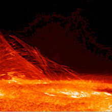
 Hinode JAXA/NASA") The surface of the Sun is an incredibly violent place that it is difficult for theorists to model or for experimentalists to reproduce on Earth. However, a paper in Science this week by Cooper Downs at the Predictive Science Inc. in San Diego and his colleagues show how a comet's close encounter with the Sun in 2011 can help us.
The surface of the Sun is an incredibly violent place that it is difficult for theorists to model or for experimentalists to reproduce on Earth. However, a paper in Science this week by Cooper Downs at the Predictive Science Inc. in San Diego and his colleagues show how a comet's close encounter with the Sun in 2011 can help us.
The Sun's surface is not only a very hot environment, but it's also subject to very strong magnetic fields produced by the Sun's interior. It is these magnetic fields that can trigger some of the most violent processes in the Sun, such as coronal mass ejections - the ejection of vast clouds of gas at very high speed, which can trigger the northern and southern lights if the collide with the Earth's magnetic field.
It is a difficult environment to model, both because of the infeasibility of building spacecraft that could survive the temperatures they would encounter flying through the Sun's atmosphere, and because of the difficult of reproducing anything so extreme in laboratories on Earth.
However, it is an environment we would very much like to be able to reproduce on Earth, as nuclear fusion reactions - reproducing the processes by which the Sun generates its energy - could be a future solution to the Earth's energy crisis.
Writing in the journal Science this week, Cooper Downs points out that even if it is difficult for us to send probes to travel through the Sun's atmosphere, nature provided just such a probe for us in 2011. In December of that year, comet 2011 W3 Lovejoy skimmed through the Sun's atmosphere, leaving a wake of steam and dust behind it, rather like the condensation trails that aircraft leave behind them.
Subsequently, this line of material has warped and distorted under the influence of the Sun's heat and magnetic field. By studying exactly how it behaves, Downs and his colleagues have produced estimates for how the Sun's magnetic field varies along the line. This is particularly valuable since magnetic field do not produce light of their own, and are normally invisible to telescopes.
Understanding how the Sun behaves is a formidable challenge and these observations are only one step along the way. Nonetheless, they provide theorists with a novel piece of data with which to constrain their models.

07:13 - Quickfire Science: HPV and Oral Cancer
Quickfire Science: HPV and Oral Cancer
This week, Michael Douglas revealed in an interview with The Guardian newspaper, that he believes the throat cancer he suffered was a result of infection with the human papillomavirus that's HPV. An infection that he believes he contracted through oral sex. Dominic teamed up with Kate Lamble to bring you the quickfire science.
Kate - Human papillomavirus or HPV is the name of a group of more than a hundred viruses which infect the skin and the membranes lining your body like the inside of your mouth or the anogenital tract.
Dominic - The virus is passed from person to person by skin to skin or genital contact.
Kate - More than half of men and women catch HPV within 3 years of becoming sexually active and most will be unaware they've contracted it because in the majority of cases, there are few, if any, symptoms.
Dominic - An HPV infection will clear up easily in over 90% of cases, but some people will experience a persistent infection which could put patients at risk of cancer throughout their lifetime.
Kate - Fifteen HPV viruses are associated with an increased cancer risk. One type, HPV 16 is responsible for around 80% of anal cancers and 60% of oral cancers.
Dominic - As well as their link with cancers, different members of the HPV family of viruses, also called warts and verrucas.
Kate - In the US, cases of throat cancers associated with the HPV infection increased threefold between 1988 and 2004.
Dominic - In the UK, an HPV vaccine has been offered to girls since 2008. But it's currently not offered to boys.
Kate - This is because we rely on the idea that immunized girls will protect the boys. However, critics argue that men who have sex with other men, or unimmunized women are still at risk. Australia recently became one of the first countries to introduce the vaccine for both sexes.
Dominic - We don't know whether Michael Douglas's oral cancer were HPV positive or negative, but the virus can be a factor in similar cases. To reduce the risk, doctors advised people to receive the HPV vaccine or use condoms or dental dams to reduce genital contact.

09:34 - Misdiagnosed manganism near Mount Etna?
Misdiagnosed manganism near Mount Etna?
Scientists in Italy have found that the surfaces of lava stones from Mount Etna, in Sicily, may be leaching manganese into the environment. Almost 1.5 million people are supplied with water from Etna's wells and these findings could help identify any health risks associated with using this water.
Antonino Gulino and colleagues, at the University of Catania, have used x-ray photoelectron spectroscopy (XPS) to characterise the surface composition of lava stones emitted from Mount Etna during activity in April 2012.
XPS involves firing x-rays at a material and measuring the electrons subsequently released from its surface layers, down to a depth of a few nanometres. XPS allowed the team to differentiate between elements in the surface and elements in the bulk, unlike bulk analysis techniques used previously.
The team found significantly lower amounts of silicon, iron, calcium and potassium, and higher amounts of aluminium, sodium and phosphorus on the surface than in the bulk. The surface manganese content was more than twice that in the bulk.
Incidence of Parkinson's disease around the volcano is well above average and doctors have been unable to rationalise these numbers. Groundwater from Etna's wells has been found to contain very high levels of some potentially toxic elements. Water samples collected in 2010 had manganese concentrations up to 2600μg/l - Italian legislation states it should be no higher than 50μg/l.
This suggests that manganese in groundwater could come from eroding lava rocks, and that the Parkinson's cases could in fact be caused by manganism - effectively manganese poisoning - which gives similar symptoms. More studies would be needed to confirm the links between manganese on the lava rocks' surfaces and in the water, and between the manganese in groundwater and Parkinson's symptoms, but the work highlights a possible source of the pollution.

12:30 - Planet caught in the act of forming
Planet caught in the act of forming
 For as long as people have been looking at the night sky, they have been wondering where our Earth came from, and by what processes it formed. A paper published in Science this week by Neenka van der Marrell at the Leiden Observatory presents new evidence that our models of how planets form are not quite right.
Theorists believe that the Sun and planets of the solar system formed when an interstellar gas cloud collapsed inwards due to its own gravitational self-attraction, around five billion years ago. The central parts of that gas cloud became the Sun, while there would have been material around that which was less tightly bound, but still in orbit around the Sun.
Over time this material - taking the form of a swirling disk called a protoplanetary disk - began to collect together into conglomerates which became planets.
Quite how this process of conglomeration occurred is less well understood. Some people have suggested that small solid particles of interplanetary material collide together within the disk and stick together.
This material certainly exists - it's called dust, and is essentially the soot which is formed in the atmospheres of previous generations of stars. The problem with the model is that on Earth, experiments invariably show that when lumps of solid material collide at high speed they tend to shatter rather than sticking together.
Moreover, as planets begin to form around stars, they would feel friction from the material around them, which will tend to cause them to slow down and spiral inwards towards their host stars quite quickly.
To get around these problems, some theorists have proposed that instead of forming out of high-speed collisions between solid particles, planets found out of swarms of dust grains which become bound together by the force of gravity before they physically cohere together.
The argument, however, has been difficult to prove without observations of planets in the process of forming, and until now no telescope has had the high resolution that would be needed to image planets forming around even the Sun's nearest neightbour stars.
In the past few months, however, the Atacama Large Millimetre Array (ALMA) has been approaching completion, and using 64 antennas spread across the Chilean Andes this is able to see planet-forming disks in much more detail than has previously been possible.
Although the telescope is not yet completed, it is already making its first scientific observations, and writing in Science this week, Neenka van der Marrell reports observations made of the planet-forming disk around the star Oph IRS 48. The observations are remarkable in that the dust around the star appears to be concentrated to one side, appearing very much like a swarm of material in orbit around the central star.
This is only one observation of one protoplanetary disk, but it shows the kind of images that we can expect from ALMA in coming years, and lends strong support to the idea that swarms of material can be present in planet-forming disks.
15:56 - What's in a name?
What's in a name?
Parents are subconsciously selecting names that linguistically portray their children as, in the case of boys, bigger and stronger, or, in the case of girls, more  feminine and petite.
That's the conclusion of a research team led by Alan McElligott who, together with his colleagues at Queen Mary University of London, analysed the top 50 most popular boys and girls names for newborns from England, Australia (NSW) and the US.
Linguists and sound scientists have shown in the past that individuals, including babies as young as 4 months old, judge words - and even made-up words - that have a lower vowel sound, like "maximum", to represent something that is bigger; conversely, words that contain high-sounding vowels that tend to be formed towards the front of the mouth - like "minimum" - tend to be regarded as representative of smaller things.
And in nature the same rules apply. Amongst animals, high pitched bleats, whines or calls tend to be used socially and to indicate friendly intent, while lower-pitched growls or roars are usually associated with aggression; the presumed reason being that a lower-pitched sound is judged to come from a bigger voicebox and hence must be inside a bigger stronger animal.
Tests on humans have shown that hearing a deeper voice in males tends to make people think of a bigger, stronger stature and hence better reproductive odds.
So, the Queen Mary team hypothesised that parents might be unwittingly adopting the same principle when naming their children, choosing names for boys that are dominated by a low vowel sound and names for girls containing a higher, sweeter sounding vowel.
By looking at English, Australian and US birth records and marrying up the most popular names with the way in which they would be pronounced locally, the team have found a highly significant association between boys names and lower vowel sounds - like Michael, and higher sounds for girls names, like Michelle.
However, the observation may not be universal. The team acknowledge in their paper, published in PLoS One, that they have looked only at English speaking nations so far. Other nationalities, or cultures, they say, might be completely different.
"We want to look at that question," says McElligott, because quite the reverse might be true in other languages. For instance, he highlights Africa cultures, where, compared with Western societies that tend to favour thinner female physiques, larger-sized, well-nourished women are preferred. Among these groups, bigger-sounding female names might be more popular.
"We won't know until we look," McElligott cautions. "We're hoping that this paper will stimulate a lot of work in this area, which no one has explored before. I normally work on the sounds that goats make, so this is a new departure for me!"

19:38 - How mood affects our taste for fat
How mood affects our taste for fat
with Paul Breslin, Rutgers University, the Monnell Chemical Senses lab in Philadelphia.
Now I'm sure we've all found ourselves comfort eating ice cream directly from  LeoSynapse @ stock.xchng") the tub at times of great stress, but a new study out this week suggests that people who are mildly depressed lose the ability to distinguish different levels of fat in foods.
the tub at times of great stress, but a new study out this week suggests that people who are mildly depressed lose the ability to distinguish different levels of fat in foods.
We were joined by Paul Breslin from Rutgers University, and the Monnell Chemical Senses Lab in Philadelphia to talk about the work he condicted with Petra Platte and her team at the University of Wuerzberg in Germany.
Chris - First of all, how do we actually taste fat because you put something in your mouth and you say that tastes sweet or bitter, but what's the taste of fat?
Paul - Fat is largely experienced as a feeling on the skin inside the mouth. So, if you put a drop of oil on your fingertips and rub them together, you can tell that there's fat there because it's slippery. And we would feel it the same way in the mouth. It has to do with lubrication of the inside of the oral cavity and everything moving around in there. In addition to that, there's also receptors for fats on taste cells. We don't know exactly what they're doing yet, but they're probably participating in the perception of any kind of food fat that we would be perceiving.
Chris - So, when you began this study, what was the hypothesis that you were pursuing here?
Paul - So, the idea is that we know that we can manipulate our body's chemistry in particular, our brain chemistry either by taking drugs that manipulate the chemistry or through stress, anxiety, depression or mood. And that they all have an impact on this. It's been observed that certain drugs in certain states can impact taste, and what we wanted to be able to do is to look at the impact of mood manipulation, manipulating the emotions of people with video clips that we're happy or sad, on people who are very mildly subclinically either depressed or anxious and see what the impact would be on their ability to perceive a variety of different stimuli in the mouth and that would include things that taste bitter, sweet, salty, sour, as well as fats that were basically dairy creme. So, taking heavy cream and diluting it down with skim milk. So, you have a whole range of levels of fattiness and creaminess to perceive.
Chris - Sounds disappointing if you like the crème brulee. Why should a person find that their taste sensations are affected by mood?
Paul - The chemicals that are involved with how neurons in the brain talk to each other are also how the taste receptor cells and various cells in the mouth communicate with neurons that sends signals to the brain, letting you know what it's your mouth. So, the cells talk to each other with these molecules. And when you have a manipulation of mood or state, you can actually manipulate those chemicals. So, we know that there are certain classes of compounds involved with depression or anxiety. Chemicals like serotonin or noradrenaline, and that the same things that have to do with affecting how you feel when you're depressed or how you feel when you're anxious that have to do with neurons communicating with each other in the brain, also has to do with how the cells that are responsible for our tasting, what comes in the mouth, talk to these neurons. So, in principle, you should be able to manipulate someone's moods say, and alter the chemicals, not only that make them happy or sad from manipulating their brain chemistry, but simultaneously affect the chemicals in the mouth that affect how your taste receptor cells talk to those neurons.
Chris - What did you find when you did that?
Paul - So, there's an observation that other people have made, that people who tend to be anxious or people who are depressed clinically, when you ask them how they perceive various tastes in the mouth - bitter, sweet, sour, salt, they tend to rate them higher. In fact, people who are anxious have a tendency to rate most seemingly higher. Things seem brighter or louder when they're anxious and tastes also seem stronger. That also tends to be true for people who are depressed. It's also been shown that when you administer drugs, pharmaceuticals that manipulate these same systems that you can acutely and reversibly make these tastes seem stronger as well. So, we were experimentally taking people with very mild subclinical depression or anxiety. These weren't clinically depressed or anxious people, and we were manipulating their mood by showing them movie clips that were happy or very sad clips, or neutral boring ones. By doing that, we were trying to manipulate their chemistry and show that we could make these tastes stronger. We happen to also give them fats to evaluate and it was not really known what would happen under those circumstances. Fats it turns out, go the other way, when you manipulate mood by giving people these happy or sad video clips, if they're mildly subclinically depressed, they become worse at being able to distinguish between levels of fat in a cream.
Chris - Do you think that's significant in a sense that if someone is depressed, they're not going to care whether they watch their weight or eat a healthy diet.
Paul - Well, there are a couple of associations that have been known from studies of people in the past. One is that folks who are obese tend to have negative emotions and people with negative emotions have a tendency to overeat. We also know that people who are obese have a tendency to underestimate fat levels in food and their fat intake, and we also know that people who have a higher body mass tends to be low in their sensitivity to fat.
Those are all just observations. We were experimentally manipulating the system and really sort of showing that what those observations that had been made in the past were really making sense. And what it suggests is, that perhaps people who tends to be heavier, have a higher body mass, tend to be slightly more depressed or have more negative affect. This tends to affect their ability to perceive fats so that if they were eating something that was say high fat, they might not be able to know that it was high fat, relative to something that were like a skim milk that had very little fat in it. And if they did that and weren't paying attention to how much fat they're eating, it could in fact make their body mass go up, which would put them into sort of a positive spiral of being heavier and having more troubles as a consequence of that.
Chris - And equally, people who become depressed, yes, there may be some motivational factors but also, they could end up eating more than they think they are - fat intake that is, and that would translate into a weight gain which could then become self-fulfilling.
Paul - Yeah, the problem with this is that if you're not paying attention to what you're eating. You already have a predisposition to overeat and if you're not aware of how much fat you're eating then there's this cycle of obesity going up, negative emotions going up, overeating and inattentiveness, or inability to perceive fat level going up and on, and on, it would go.

26:46 - Get Lost! Lying about locations with GPS
Get Lost! Lying about locations with GPS
with Markus Kuhn, University of Cambridge
Dominic: - We've all become used to using GPS satnav units in cars and on phones which can pinpoint where we are. But now, computer scientists have shown how people could fool these systems into lying about their location. Markus Kuhn from the computer laboratory at Cambridge University works on what's called GPS spoofing. Now Markus, first of all, we're used to these satnav systems in our cars, but how do they actually work out where we are?
Markus - So, there are 24 satellites in an Earth orbit and they're basically a bit like a speaking clock. They tell us all the time very precisely within a nanosecond what the time is and they also tell us at the same time where exactly within a metre they are located. If you know yourself what the time is, you can find out how much the signal has been delayed. From that, you can calculate how far away you are from the satellites. Then if you know how far away you are from 3 satellites, you can intersect three spheres and know where you are. If you don't know the precise time, you need to forth satellite to resolve the ambiguity and this way, you can calculate by looking at 4 satellites precisely what's your time and what's your location.
Dominic - So, it's a process of triangulation by knowing your distances from 3 or 4 satellites above your head. Now how maliciously can you go about tricking that system?
Markus - So, the GPS signal consists actually of 2 signals. There is a signal exclusively reserved for the US military and there is a public signal. That public signal makes it possible for all of us to enjoy GPS in our smartphones and in our satnavs. However, this signal is highly predictable. I know in advance what these satellites are going to broadcast over the next couple of hours that makes it possible for me to receive it but that also makes it possible for me to synthesis one of these signals. So, I can build a device that creates a fake signal and I can send it out and I can make a GPS receiver believe that it's actually somewhere else or at a different time.
Dominic - So, if we take an example, we've got cars going past outside the window. If I wanted to trick a satnav in one of those cars into say it's somewhere other than where it is, how could I do that?
Markus - You could send out a signal but the particular applications that I'm worried about are not so much satellite receivers that are elsewhere. There are other applications where the person who owns the satellite receiver may have an incentive in that receiver showing a wrong result because the receiver doesn't quite work in their interest. So, there are systems where a car insurance company gives you a satellite receiver and they charge you an insurance fee based on when and where you have been driving. There are lorry fleet management systems where an employer monitors the performance of their drivers whether they are speeding, whether they are taking unauthorised detours by looking at data from the satellite receivers. And in those situations, it's very tempting for the people who have control over the receiver to just disconnect the antenna and connect instead a little box that creates a spoof signal and makes the receiver believe it's elsewhere.
Dominic - So, what you're saying is if I hire a car, and I know where the GPS receiver is in the car, I would disconnect the antenna; it wouldn't then see the real satellites. If I had a computer next to me that was generating a fake signal, I could then feed that into the receiver and make it think it was somewhere entirely different.
Markus - This may initially sound a bit far fetched, but we have already seen quite a lot of manipulation of a similar older system - tachographs in lorries which records how fast someone has been driving. And police have recovered from lorries little devices inserted into the line between the gear box sensor and the tachograph. With a remote-control key-fob, a lorry driver can easily reduce the speed by 10%, by 20% or simulating a break such that the record is faked. One worry is that over time, as the technology for simulating these signals becomes simple and cheaper, the same thing will be happening with GPS based systems.
Dominic - So, what's your aim in researching techniques like this because I'm guessing at the computer laboratory, your job isn't to find tricks that people can use to basically do insurance fraud?
Markus - So, as security researchers, we see our job in anticipating what sort of problems there will be in a couple of years' time and this is important because the innovation with something as big as a satellite navigation system doesn't happen very quickly. These satellites last a bit over 10 years and they have to be replaced over 10 years, and it takes a long time to develop them. So, if you want to make a modification to how the system works, you basically have to start thinking about this 15 years into the future. By that time, there may be a lot of applications that rely on these signals. The signals at the moment are not designed really for security applications.
Dominic - And how could we go about making this more secure? Would it involve people going out and buying new satnav units and replacing satellites?
Markus - So, there are already a couple of techniques that can be used today, but they are mostly used in military systems. You can have not just a single antenna, but you can have several antennas in your GPS receiver and that allows you also to find out for which direction the signals come. If there is someone trying to jam you or trying to confuse you with a spoof, fake, signal you just ignore them and you stick to the directions where you expect the signal to come from the satellites. That isn't really practical in consumer electronics where everything has to be very cheap. You don't have space for more than one antenna in your smartphone and it would be expensive to fit 8 separate antennas around your car. So, what we're looking at is adding additional information to next generation satellite signals and at the moment, these signals are highly predictable. One technique is that you create a little bit of unpredictability. You send out data that changes randomly and then you can use technologies like digital signatures to verify that this unpredictable data was indeed correct, and also that it arrived exactly at the time at which you expected it. One difficulty with satellite navigation signals is they consist of two things. They consist of data that's being broadcast about where the satellites are at the moment, and you can use cryptography, digital signatures, in order to protect that data, such that it can't easily be faked. However, in navigation signals, you also have to authenticate the very precise arrival time of the signal. So, you have to get right within a few nanoseconds, when did the signal arrive? And it's possible to build spoofing devices that take the original satellite signal and delay it by a random amount and shift you elsewhere. It's rather difficult to prevent that sort of technique. There is one suggested technique that makes use of a property of the existing GPS satellite system, namely that if you don't know what the signal looks like, you can't actually receive it. The satellite signal is extremely weak. It's basically a light bulb worth of transmitter power at 25,000 kilometre altitude and the only way you can receive that signal is by knowing at once what it is. And then you use statistical test to confirm, "Yes, I have actually found the signal where I expected it." If you designed the signal such that you don't tell people in advance what it looks like, you just send out a random signal. No one can receive it. Then a couple of seconds later, you reveal what was the signal that you broadcast and then everyone can go back in their recorded data and search for it and find it. Then what a spoofer who modifies a signal that comes down from the satellite only can do is they would have to delay that signal by a couple of seconds. And with delay of a couple of seconds, you can easily detect by just having a local clock that say, once a week you re-synchronise over the internet. So, that's one of the 2 or 3 different approaches that are at the moment, being discussed what can go into next generation GPS satellite system. And it's not just GPS: Europe is at the moment launching a system. The Russians have already a system. There's a Chinese system under deployment, so we'll soon have 3 or 4 different operational constellations of satellites.
Dominic - So, in the future, the key to making these systems secure will be to make them unpredictable so that you can't synthesis these signals. Thanks, Markus. That was Markus Kuhn from the computer laboratory at the University of Cambridge.

35:54 - Accurate Indoor Tracking
Accurate Indoor Tracking
with Ramsey Faragher, University of Cambridge
This week Ramsey Faragher joined us from the Digital Technology Group at Cambridge University. He's trying to make it possible to locate where people are in a room or building, with high precision.
Chris - So, how do we locate people in buildings at the moment or how are we trying to do that?
Ramsey - So, there's a couple of standard schemes. One of them would be to deploy fixed infrastructure specifically in the environment which would cost a lot of money; putting beacons in the environment and giving people special receivers that they can go around with and be positioned by. A much cheaper scheme is to use things that are already pervasive in the environment and that's what I'm looking at. So, for example, as I move through a given building, I can tell the difference between different rooms because I can see the colours of the wallpaper and pictures, and the size and shape of the rooms. A smartphone can do a very similar thing in radio eyes and magnetic eyes, and a smartphone can learn what different rooms look like by the different signal strengths in the radio and different magnetic patterns. What I work on is a way of making a device learn about the building and learn about what all the rooms look like, so that when you come back, you can very accurately locate where you've been in that building.
Chris - So, you as the holder of the smartphone would be able to localise where you are and where you have been. What about turning it around and the building knowing where you are? I could see that would be useful in situations like for instance fires or even patient care in a hospital.
Ramsey - Yeah and that's certainly very possible too. So, a way of doing that is that you choose to transmit the data that you're working out to someone so they can know where you are. But certainly, there are things that you can do to allow an infrastructure in an environment to work out where people are. So, a typical example is you put receivers through the environment and when someone is texting or on the internet, on their phone or they're making a phone call, the receivers through the environment can pick up these signals and work out the time difference of arrival of all the different signals so they can effectively work out who you're closest to as you move through the environment. And very similar to the techniques we've just been discussing about GPS, given some receivers spread through the environment, you can work out where the transmitter is, the person who's texting or calling as they move through the environment. You can work out their position as they move through the environment by receiving the data from them.
Chris - It sounds actually quite a simple problem to surmount, but the fact that we're not doing this means there must be some wrinkles. So, what are the wrinkles?
Ramsey - So, it's certainly a very simple problem when the world is a nice perfect sphere and you're in a vaccum and all that kind of stuff. The problem is in an indoor environment, it's extremely complicated. The metal in environments, the effect of signals going through walls, all these kind of stuff, and the technique that I'm working on where the system learns what the environment looks like as it moves around actually flips the whole problem on its head. The more complicated the signal environment, the nastier it is, the more unpredictable the nature of the signals, the better the positioning and instead of trying to model and predict, and work out what the signal should look like in a given place, you just record what it looked like when you were there, record all of these patterns, all of these signals, and you piece together what that environment must look like and what this really complicated pattern of radio and magnetic fingerprints looks like.
Chris - That though requires the device to slowly build up a picture of its world it's living in. what about the first time you go into a novel environment? It's not going to know anything then, is it? So, how will it acquire that information or give meaningful information to start with?
Ramsey - This is the kind of key of the whole system. You have some way of estimating your motion around the environment. So, the typical one we use is a modern smartphone is full of sensors - accelerometers, gyroscopes, a magnetic compass, a barometer, they're designed for gaming and making your screen  Mr3641 @ wikipedia") rotate when you turn the phone round and in actual fact, you can do a really good job of tracking a user through an environment as they move. So, I walk along with my phone held out in front of me and the shaking that goes on in the phone, my software can recognise that and infer that I'm walking. It can use the gyro-smoothed compass to infer a heading that I'm walking along. Using that technique, you can get a good estimate as a person as they move around the building.
rotate when you turn the phone round and in actual fact, you can do a really good job of tracking a user through an environment as they move. So, I walk along with my phone held out in front of me and the shaking that goes on in the phone, my software can recognise that and infer that I'm walking. It can use the gyro-smoothed compass to infer a heading that I'm walking along. Using that technique, you can get a good estimate as a person as they move around the building.
The problem is, the errors accumulate with that system. So, if I walk 100 metres, I might have a 2-metre error. If I walk a kilometre, I might have a 25-metre error. The more I move around in my building, the worse it gets, but it's good enough to start piecing all these fingerprints together. What the system basically does is, it recognises when it's come back to a place it's been before. It sees a sequence of fingerprints that match the past and it can observe a correction that it needs to drive through the system and it corrects its current position estimates, and the journey as to how you got there. It effectively keeps tidying itself up and the longer you operate in a building or if multiple people move through a building and they can all share data, then you can very quickly build-up these maps. The clever bit then comes when you've got a good enough map to turn off all of these sensors and just use the radio and the magnetic fingerprints which is a much cheaper battery life-wise way of navigating around an environment.
Chris - So, that tells me where I am in a building. How could we actually use knowledge of that data?
Ramsey - Indoor location based services currently estimated to be worth billions of dollars, just from the consumer point of view of things like pushing location specific adverts to people. There's an interest in the ability to do things like target a text message or a push notification to somebody who's in a rival store to your store. They might be looking at classic CDs in some shop and you can push them. It's tagged to that little advert that says, "I see you're currently looking at the classics section in that store. If you come to my store, here's a 5-pound gift voucher. It's valid for an hour and here is the route from where you're stood right now to where my shop is" and that's worth a lot of money.
Beyond adverts and the consumer stuff, the emergency services would love this kind of capability so that when I make an emergency call, they know exactly where I am inside a building to the floor and the room, never mind, just the building I'm in. But also tracking the emergency services themselves - the safety and security of firemen moving through a building, knowing that outside in the fire truck someone is watching them move through that environment and knows to the room where they are. It's a huge safety line and of course, from the military sector too, looking after soldiers moving environments as well.
Chris - It sounds pretty intrusive though, but I can see why this will be valuable from, if we were sort of designing an office or designing a public place and we wanted to see how the average person moved through it. You could achieve much better formatting in order to safeguard people's route through it. If it's a minefield, taking your military analogy of if it's just an office, finding your way from the kitchen to the photocopier to cut down wasted time or maximise contact with people so you're more likely to have interactions that are meaningful in the workplace, that kind of thing.
Ramsey - Yeah. I mean, it's certainly only intrusive of course if you've not chosen to take part in this, but the whole point is, I'm taking GPS that we love and depend upon this life-saving technology and moving it into the indoor environment so we can still benefit from all of those capabilities. I'm sure you've been in a supermarket at some point, trudging up and down the aisles, wondering where the hell the beans are or whatever. The capability to fire up your phone and do satnav at the shelving level in a big supermarket is something that everyone would opt into.
Chris - Undoubtedly, where can I buy shares? I mean, is this actually good to go? Have you got this system written or are you at the stage where you've got the bare bones of this and you're beginning to see it implemented or do trials? Where's it at?
Ramsey - This runs live right now on my phone. I'm working on smartphone applications to do this kind of stuff. One of the fantastic things about smartphones is the sheer pace at which they're improving and the kind of approaches I use and the kind of levels of software machine learning that goes on. Ten years ago, you would've needed a desktop computer that was quite an expensive one. Nowadays, you can deploy it all on a smartphone and do it all live on a smartphone. It's only improving - the number of calls on the phones, number of sensors in the phones. So, it's a great time to work on this kind of stuff and it's real time and ready to go right now.

44:39 - Using GPS to track volcanic ash clouds
Using GPS to track volcanic ash clouds
with Kristine Larson, University of Colorado
Dominic - GPS might be best known as navigation system, but researchers have also found it a very powerful tool to measure environmental changes on Earth. We're joined by Kristine Larson from University of Colorado who's developed a novel way to use GPS detectors to monitor volcanic plumes such as the ash cloud which grounded flights across Europe when the Icelandic volcano erupted in 2010. Kristine, how do people traditionally monitor ash clouds coming out of volcanoes?
Kristine - I think it's a little bit like the way we think about monitoring weather storms. They use satellite imagery. You'll see the photos of the plumes moving and that works fine if the weather is good and you have a good satellite image. But of course, you don't have those images all the time, depending on the cloud situation. Another powerful tool for studying plumes is radars. The problem with that is just you don't have radars where you have volcanoes. So, you have to really be lucky and have the equipment you need to study that plume, and we just don't have enough equipment around all the active volcanoes in the world.
Dominic - Now, you've been working with GPS sensors around these volcanoes. First of all, why were the sensors put there in the first place?
Kristine - Right, I've been working on data from Alaskan volcanoes and those were put there by colleagues of mine at the University of Alaska in the Alaska Volcano Observatory and they were using GPS in what I would call the traditional sense. I realise the last couple of people you interviewed talked about the real-time navigation that you think of when you think about using GPS in your phone or in your car. But there's a lot of people in my business, which is science, that use it to study how the ground deforms, and we use that to very accurately monitor - in the case of a volcano - whether there's an eruption likely to occur. Before an eruption, the ground starts to inflate. The magma chamber inside the Earth starts to inflate and that causes the ground to move. You have to have very precise GPS receivers to detect that. So, I had colleagues that had put GPS receivers there for a completely different purpose. They were going to measure the magma chamber inflating. I just recently had the idea of seeing if we could see the plume by looking at the data from a different vantage point.
Dominic - So, how can that data from those sensors tell you about ash which is actually in the atmosphere, above those sensors?
Kristine - Right. I mean, you have to look at things backwards and I want to credit my colleagues at the University of Alaska. They had noticed that they thought they could see the effect of a plume on their positioning data. So, they were measuring latitude, longitude, and height. They noticed that during the eruption, the ground moved a lot. Well, that's not too surprising. You'd think, "oh, an eruption causes the ground to move". But they were 5 or 6 kilometres away, and the ground should not have moved as much as it did. And so, they correctly hypothesised that the plume was making the GPS positions wrong, just because it was an error that was unaccounted for when they calculated positions. So, they had first seen this, but when I looked at the data, I just said, "Well, you know, calculating position and then inferring that there was an eruption because the positions look bad, it sort of seems like a difficult way to look at the problem. So, I sort of looked at it differently and said, "If I were a GPS signal travelling through an ash cloud, that would cause the signal to be reflected around. Not as much as of the signal would get into my antenna because it would be, if you will, deflected by all these particles, these ash particles. GPS was not meant to work in ash plumes and so, I hypothesised that that would cause signal power to go down. So, instead of looking at the positioning data which is what the rest of us use GPS for, I looked at the signal strength data and that doesn't tell you anything about position. It really only tells you how good your reception is, just the same way your cell phone tells you how good your reception is too. So, I looked at the signal power and I could very clearly see when there was a plume.
Dominic - So, you've got this sensor on the ground and it's hooked up to various satellites in the sky. And you can see the signal strengths from those various satellites, and you can predict what those signal strengths ought to be. If that's less than you expect, then you know there must be something in the way so you infer that there must be an ash cloud there?
Kristine - That's right, because you know these satellites run 24 hours a day, 365 days a year. Signal strength does not change. The military run them to specifications. And so, I compared it to the day when there was the eruption, and I noticed the signal powers were perfectly fine in most directions, i.e. the directions that didn't go through the plume. So, it turned out only 2 or 3 satellites were being affected by the plume. So that tells me where the plume was, and if I made certain assumptions about where the volcano was, which we know - where it was, or at least I looked on Wikipedia and found out where it was - you could infer how high the plume was and things like that because we know where the satellites are. One of your previous speakers talked about that. We know where they are and that tells us which satellite is affected by the plume.
Dominic - So, you've got this sensor on the ground and it's hooked up to various satellites in the sky. You can see the signal strengths for the various satellites, and you can predict roughly what they ought to be. If that's less than you expect then you know that there is something blocking it so you infer that there must be an ash cloud there.
Kristine - That's right because you know, these satellites as you all know, they run 24 hours a day, 365 days a year. Signal strength does not change. The military run them to specifications. So, I compared them to the day when there was an eruption, and I noticed the signal powers were perfectly fine in most directions, i.e. the directions that didn't go through the plume. So, it turned out only 2 or 3 satellites were being affected by the plume. So that tells me where the plume was and if I made certain assumptions about where the volcano was, which we know - where it was, or at least I looked on Wikipedia and found out where it was - you could infer how high the plume was and things like that because we know where the satellites are. One of your previous speakers talked about that. We know where they are and that tells us which satellite is affected by the plume.
Dominic - Now, I think this isn't just about ash? You've actually managed to measure snow and vegetation as well?
Kristine - That's exactly right, but I do it a little bit differently. So, in the case of the volcano, I look and see if signal strengths has been degraded if you will, less signal getting into my antenna because of the ash that is basically disrupting the signal transmission. To measure snow, what I do is again, I sort of look at a normal day when there is no snow. I look at the effect of GPS signals that bounce on the ground and reflects back up to my antenna. That has a very characteristic frequency and then I compare it to a day when there is snow and if the reflective signal has a different frequency then because there's these snow layers, so I basically look at the patterns of reflections to tell me whether the - basically, if the ground is moved. If there's snow on the ground, that makes it look like the ground is higher and then when the snow melts, it gets back to where it originally started. Similarly, if there's vegetation on the ground, that changes the balances of the ground as well. But it's all using signal strength data and it's all using the same equipment that other people use to measure latitude, longitude and elevation.
Dominic - At the moment, it sounds like you're using arrays of sensors which are being put down for other purposes, for looking at ground movements. But given how much you're managing to infer from this, it sounds like it might be worth building arrays in areas where you're interested in monitoring snow and vegetation, and so forth.
Kristine - That's exactly what we're going to try to do. Since we are doing something pretty simple, we're trying to make the GPS sensors cheaper because for example, the reason we all have GPS sensors on our phone is because people have come up with very cheap GPS sensors to use there. For the kind of thing I'm talking about, I think we could do the same thing. So, what we'd like to do is we've shown that you can use these GPS receivers that were put out to measure plate motions and volcanic motions. We've shown you can measure snow with that like you said. But we'd like to do it in arrays with cheaper sensors and that's what we're working on. I have some students working on that and some colleagues working on that so that we can provide a cheaper environmental sensor.
Dominic - Thanks very much, Kristine. I'm sure that's something we'll be keeping an eye on in months ahead. That was Kristine Larson from the University of Colorado.

51:55 - How high can a mountain be?
How high can a mountain be?
Hannah - So, how do mountains form and what's to stop them reaching further up into the sky?
Nicky - My name is Nicky White and I'm a Geologist who works at the Department of Earth Sciences in the University of Cambridge. It's well-known that the Himalayas are amongst the highest mountains on Earth with Mount Everest peaking at just over 8 kilometres and an important question is, why on Earth do you not get mountains that are higher than that? The main reason is that there are two things fighting against each other when you make mountains. First of all, you have the plate forces. So, for the Himalayas, India is colliding with European, the Eurasian plate and forcing the crust to become thicker which pushes the Himalayas up in the air. But something else is going on that's often not talked much about which is that mountains eventually tend to fall down, just through their own weight. And the important concept here is something called viscosity which if you like in the runniness of the rock that's inside the mountains. A useful analogy is something like syrup. So, if you imagined that you created the Himalayas out of syrup, I think it would be easy to see that as soon as you start pushing the mountain up in the air, it also starts to fall down because the syrup will flow out sideways. It's just the same in the Earth. So rocks are not quite as runny as syrup, but they still have a certain ability to flow. So it means when you build a very large mountain chain, as soon as you start to reach a certain height, it will begin to fall down under its own weight. So, the Himalayan chain is actually beginning to squirt out sideways, mostly towards China which means we're probably at the limit of the maximum possible elevation achievable on Earth. On other planets such as Venus and Mars, the viscosity of the rocks may be different which is why you can achieve higher mountains.
Hannah - Thanks, Nicky. So, mountains fall down due to their own weight and the height at which they start to fall is due to how runny the material is that they're made up from. There's actually a number called the Argand number which is essentially the weight of the mountain divided by its runniness and this helps us to know how high a mountain can grow. Everest is just about at its max.


Comments
Add a comment